Compartir
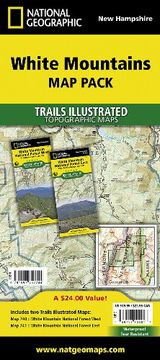
White Mountains National Forest, Map Pack Bundle: Trails Illustrated Other Rec. Areas (National Geographic Trails Illustrated Map) (en Inglés)
National Geographic Maps
(Autor)
·
National Geographic Maps
· Mapa
White Mountains National Forest, Map Pack Bundle: Trails Illustrated Other Rec. Areas (National Geographic Trails Illustrated Map) (en Inglés) - National Geographic Maps
$ 23.23
$ 33.18
Ahorras: $ 9.95
Elige la lista en la que quieres agregar tu producto o crea una nueva lista
✓ Producto agregado correctamente a la lista de deseos.
Ir a Mis ListasSe enviará desde nuestra bodega entre el
Martes 14 de Mayo y el
Jueves 16 de Mayo.
Lo recibirás en cualquier lugar de Estados Unidos entre 1 y 3 días hábiles luego del envío.
Reseña del libro "White Mountains National Forest, Map Pack Bundle: Trails Illustrated Other Rec. Areas (National Geographic Trails Illustrated Map) (en Inglés)"
- Waterproof - Tear-Resistant - Topographic MapsThe White Mountain National Forest Map Pack Bundle is the perfect companion to anyone planning a trip the stunning White Mountains of New Hampshire. The White Mountains are famous for thier rugged peaks and stunning beauty. This Map Pack combines two maps that cover the White Mountain National Forest in wonderful detail. The entire New Hampshire section of the Appalachian Trail can be found on these maps. Franconia Notch and Crawford Notch State Parks are shown as well as Mount Washington which is known for the most extreme weather in the country. Also shown are hiking trails with milage between intersections as well as points of interest such as campgrounds, visitor centers, lookout towers, and more.Buy the Map Pack and save 15%!The White Mountain National Forest Map Pack includes: Map 740:: White Mountain National Forest West [Franconia Notch, Lincoln]Map 741:: White Mountain National Forest East [Presidential Range, Gorham]Every Trails Illustrated map is printed on "Backcountry Tough" waterproof, tear-resistant paper. A full UTM grid is printed on the map to aid with GPS navigation.Map Scale = 1:70,000Sheet Size = 37.5" x 25.5"Folded Size = 4.25" x 9.25"
- 0% (0)
- 0% (0)
- 0% (0)
- 0% (0)
- 0% (0)
Todos los libros de nuestro catálogo son Originales.
El libro está escrito en Inglés.
La encuadernación de esta edición es Mapa.
✓ Producto agregado correctamente al carro, Ir a Pagar.

